Route Information 地點資料:
1. Tuen Mun So Kwun Wat Tsuen 屯門掃管笏村
Here Qin Shan ( 青山 ) stands facing Jiujing Mountain ( 九徑 ) . The terrain between the two mountains form a gateway. The Ming and the Qing Dynasties used to station soldiers there. Thus the name Tun ( 屯 station of soldier) Men ( 門 door/gateway) .
青山與九逕山相望,巍峨高山寺,二山之間地勢形成一門戶狀;明清年代朝庭曾派官兵於此地屯駐,故稱屯門。
2.JiuJing Mountain Ancient Battle Field 九逕山古戰場
The Portuguese was in Macao since 400 years ago. They used to be translated as “ 佛朗機 ”. According to the Xin’an County Records, dated back to 1516 to 1521, the Portuguese fleet occupied Tuen Mun 屯門 for almost 7 years. Wang Hong ( 汪鋐 ) , the flag officer of the Ming Dynasty, received orders to drive it out. He destroyed the Portuguese army in the Jiujing Mountain. Thereafter, Portuguese made many attempts in different ways and then finally entered Macau.
葡萄牙古譯作「佛朗機」,東來澳門已400餘年。據新安縣誌記載:追溯1516年 – 1521年間,葡人艦隊曾侵佔屯門,為時接近7年。明海道汪鋐奉命帶兵驅逐,殲「佛朗機」於九逕山。繼後,葡人輾轉才進駐澳門。
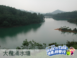
3.Tai Lam Chung Reservoir 大欖涌水塘
「 Lam 」 ( 欖 )means rivers and streams. Its originator was Guang Qiu Valley ( 廣裘山谷 ) of which the water flows to form a big and a small rivers, known as the Great Lam ( 大欖 ) and the Little Lam ( 小欖 ) . There were villages built in the valley. Some of the more well known villages are the Great Lam Village ( 大欖村 ) and Guan Wu Di ( 關屋地 ) . They have all been submerged to the bottom of the lake.
「欖」者,河溪也。大欖涌水塘前身為廣裘山谷,谷內流注大小河涌各一,稱「大欖」和「小欖」,谷地築有小村莊,較著名為「大欖村」及「關屋地」惜現已湮沒湖底。
Tai Lam Reservoir was the first reservoir built after the Second World War. The project started in 1952 and was completed in 1957. It has been almost 100 years since the first reservoir Pokfulam Reservior ( 薄扶林水塘 ) in Hong Kong was built. After its completion, it had been the biggest reservoir with a capacity of 2,050 cubic meters until Shibi Reservoir was built. Since then, there is no more valleys that are suitable for building reservoir. The larger reservoirs like 船灣淡水湖 and 萬宜水庫 were built by intercepting the sea.
大欖涌水塘為戰後興建的第一個水塘,1952年開始工程,1957年竣工,距離全港第一個水塘「薄扶林水塘」(1860年),相去已近百年。大欖涌水塘建成後,為當時存水量最大的水塘(2,050立方米),直至石壁水塘落成,才取代了存水量「一哥」的位置。之後再也找不到適合的山谷建築水塘。繼後更大型的船灣淡水湖和萬宜水庫,都是從海中截流而成的。
The ancient villages, fields and paths will emerge from the bottom of the lake during dry seasons. And when reservoir storage is abundant, the undulations and hills of the valley will twinkle like emeralds in watery blue reaching far beyond the horizon . The beautiful scenery wins itself the title of mini-Thousand Island Lake ( 千島湖 ). When you are there, you can experience the natural beauty of lakes and mountains and feel like stepping into a Chinese landscape painting .
今天,若逢乾旱季節,湖底會重現昔日村莊的田畿、古道等遺跡;又若存水量豐足,則谷地原有的丘陵山崗,仿如綠寶石般蕩漾於萬頃碧波,迷人景致素有「小千島湖」之美譽。置身其中,湖光山色,雲天映照,構成了一幅如詩如畫的山水圖。
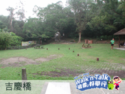
4.Wing Kat Bridge and Kat Hing Bridge 永吉橋和吉慶橋
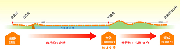
About noon, we will arrive at a spacious grassland which is surrounded by old trees and blooming flowers and their scent. It is an ideal place for a prolonged rest during the walk.
中午時抵達一處廣闊的美麗草坪,此地古樹環繞,草木欣榮,四野花香,實為大休的理想地點。
In the past, the villagers had to cross the rivers seven times when they went out or returned home. Thus the name seven-time-cross-river ( 七渡河 ). Not far from the grassland is a small stone bridge called Young Ji Bridge ( 永吉橋 ). The bridge was built in 1914 with funds pooled by the villagers. This name was used for several decade until 1982 when a bridge monument craved in1868 was found near Wing Kat Bridge ( 永吉橋 ). The monument recorded that there once was a Kat Hing Bridge ( 吉慶穚 ). Since then both Kat Hing Bridge ( 吉慶穚 ), and Wing Kat Bridge ( 永吉橋 ) are used.
從前鄉民出入,必須渡過此處溪流,每程?越渡河合共七次,故稱「七渡河」。草坪不遠處築有一小石穚,建於民國三年(1914年),由鄉民捐資興建,稱為「永吉橋」,已歷數十載。但1982年於永吉橋附近卻發現一塊同治7年(1868年)的「建橋碑」,記載此地原來有一道「吉慶穚」,因此,永吉橋又復稱為吉慶橋。
5.Yuen Tsuen Ancient Trail 元荃古道
After the lunch break, we will ride on the Yuen Tsuen Ancient Path ( 元荃古道 ). The record of Yuen Tsuen Ancient path can be dated back to more than 300 years ago when is the early Qing Dynasty. At that time, Yuen Tsuen Ancient Path is the main mail road from Yuen Long ( 元朗 ) to Tsuen Wan ( 荃灣 ). According to the written records, the villagers of the Eighteen villages in Yuen Long would transport their farm products along the road to sell in exchange for some daily commodities in Tsuen Wan. SoYuen Tsuen Ancient Path ( 元荃古道 ) was not only a road for in-and-out mails but also a trade route.
中午大休後進入「元荃古道」,「元荃古道」的記載可追溯至清朝初年,距今3百餘年,為元朗通往荃灣的一條主要通道。據記載,元朗十八鄉的村民,很多時會把農穫沿古道運出荃灣販賣,再換回日用品。所以,「元荃古道」除了是一條出入通道,也是「貿易大道」。
Although Yuen Long Old Market ( 元朗舊墟 ) and later the New Market ( 新墟 ) are the main local markets, most villagers of the Yuen Long Eighteen Villages chose to transport and sell the products in Tsuen Wan so that their goods become “more foreign” and could command better prices.
雖然,元朗舊墟及後來的新墟是當地的主要貿易市場,但基於物離鄉貴,元朗十八鄉的村民,仍多會選擇將農穫運往荃灣販賣。
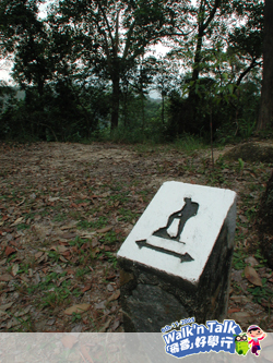
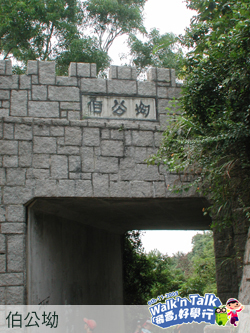
6.Pak Kung Au 伯公坳
This is the main col where the villagers nearby can come in and go out . Towers and ancient temples were built to protect the safety of the villagers in their traveling. When you are here, you can walk along the Ancient Trail to Tai Tong Laichee House where you can have the coach to pick you to the city.
附近村民出入的主要山坳,築有小城樓、古廟宇,祈求神明保佑鄉民往來平安。至此,沿古道落元朗大棠荔枝山莊專車接返市區。
(
There is another route: go from East Pak Kung Au and you can go to Nam Hang Pai
另有一處東伯公坳可落南坑排)
|